Category Archives: Recreation and Sports

Chesapeake Beach Rail Trail

 MUTCD_D9-6_svg Handicapped

 MUTCD_RS-017_svg Pets on Leash MUTCD_RS-068_svg Hiking Trail MUTCD_RS-076_svg Wildlife Viewing

The Chesapeake Beach Railway Trail runs alongside Fishing Creek in the small town of Chesapeake Beach, in Northern Calvert County, partially on the right of way of the long abandoned Chesapeake Beach Railway.  The creek is a significant watershed that empties directly into the Chesapeake Bay.  The entire trail project lies within the Chesapeake Bay Critical Area, and offers scenic views of the creek itself, hundreds of acres of surrounding marsh and forest, and includes two bridges across the creek and several timber walkways either over the creek or marshland.  Wildlife is abundant, and visitors to the trail are quite often treated to sightings of bald eagles.

Three Notch Trail

MUTCD_D9-6_svg Handicapped MUTCD_RS-068_svg Hiking Trail MUTCD_D11-1a_svg Bicycles MUTCD_RS-017_svg Pets on Leash

The Three Notch Trail is a ten ft. wide, asphalt multi use trail is being constructed along the 28-mile County railroad right of way which runs south from Hughesville (in Charles County) to Lexington Park (to the Patuxent River Naval Air Station).  The trail, in northern St. Mary’s County, provides recreational, tourism and transportation opportunities and will promote the health and wellness benefits of hiking and biking.

Phase one begins at Route 236 in New Market and proceeds north to just beyond the County line, for a distance of about 2.25 miles.  Also, Phase five of the trail is now open, running from John Baggett Park in Laurel Grove to MD 5 in Mechanicsville.

Other phases of the trail are planned for construction and opening in the near future.

Indian Head Rail Trail

IHRTLogo

10390 Theodore Green Boulevard, White Plains, MD 20695
Phone: 301-932-3470 • http://www.charlescountyparks.com

 MUTCD_D9-6_svg Handicapped  MUTCD_RS-068_svg Hiking Trail  MUTCD_D11-1a_svg Bicycles  MUTCD_RS-076_svg Wildlife Viewing  MUTCD_RS-114_svg Interpretive Trail

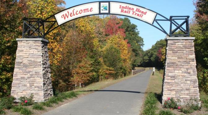
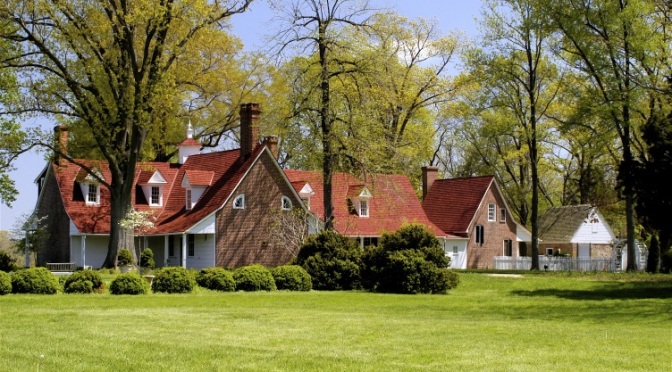
The Indian Head Rail Trail (IHRT) is located just 18 miles south of our Nation’s Capital in Southern Maryland.  The trail has a gentle grade that is perfect for trail users of all skill levels.  From the town of Indian Head, the trail quickly transitions into a very unique natural outdoor experience with surroundings of mature forests, natural wetlands, and farmland.  The trail continues for 13 miles ending on Theodore Green Boulevard in White Plains.

Along the IHRT there are interpretive signs that highlight various natural habitat areas and wildlife species, giving visitors the opportunity to view beaver dames, bald eagles, wild turkey, white tail deer, and herons.  This multi-use trail provides walkers, runners and cyclists a serene place to enjoy recreation away from the congestion of traffic.

Trail Amenities

  • A paved 13 mile long, ten foot wide path
  • Wildlife viewing areas
  • Restroom facilities
  • Pavilions and benches
  • Interpretive signs
  • Mile markers
  • Drinking fountains at trail heads

Trail Etiquette

  • Keep to the right of the trail except when passing
  • Move off the trail when stopped
  • Cyclists (should give an audible “on your left” warning when passing
  • Ride/walk single file during busy periods
  • Dogs must be kept of 6 foot non-retractable leash
  • Familiarize yourself with all trail rules
  • Respect wildlife by keeping a distance and limiting your stay
  • Obey all traffic signs, stop at all road crossings and yield to oncoming traffic
  • Be aware of your surroundings, know your location on the trail and carry a cell phone
  • Respect the rights and privacy of adjacent property owners

Printable Trail Map

Directions to Trail Access Points

Indian Head (Trail Head) – Follow Route 210 south to Indian Head. Parking is located at the Village Green Town Park. T he trail starts at Mattingly Ave about ½ mile from parking area, follow signs.

Route 224 – Follow Route 301 to La Plata and turn onto route 225 west.  Travel approximately 9.3 miles and turn right onto Route 224. Parking is about ½ mile on the left.  Follow Route 201 to Bryans Road and turn onto route 224 south.  Travel approximately 3.8 miles and parking will be on your right. Parking for about 20 cars.

Middletown Road – From Route 301 turn onto Route 227 (Marshalls Corner Road).  Travel 1.7 miles and turn right onto Middletown Road.  Trail parking is approximately ¼ mile on right. Parking for about 16 cars.

Theodore Green Boulevard (Trail Head) – Follow Route 301 to White Plains, located just south of Waldorf.  Turn onto Theodore Green Blvd and trail parking will be located about 3/10 of a mile on the right. Parking for 75+ cars.

St. Mary’s River State Park

21250 Camp Cosoma Road, Callaway, MD 20620
Phone: 301-872-5688
http://www.dnr.state.md.us/publiclands/southern/stmarysriver.asp

 mutcd_rs-054_svg-boat-ramp MUTCD_RS-063_svg Fishing Area  MUTCD_RS-117_svg Hand Launch Small Boat Launch  MUTCD_D11-1a_svg Bicycles MUTCD_RS-118_svg Kayaking  MUTCD_RS-068_svg Hiking Trail

Situated at the north end of the St. Mary’s River watershed, in the center of the county, the park consists of approximately 2,000 acres of land with a 250-acre fishing lake.  The relatively flat landscape of St. Mary’s County is not usually thought of as mountain biking terrain; however, the nine-mile course encircling the 250-acre lake at St. Mary’s River State Park is a little known treasure.  This course is also available for hiking.

Point Lookout State Park

11175 Point Lookout Road, Scotland, MD 20687
Phone: 301-872-5688
http://www.dnr.state.md.us/publiclands/southern/pointlookout.asp

 PHT logo Star-Spangled Banner NHT
 CAJO-LOGO-high-res-jpeg  MD Civil War Trails logo  ChesBayGatewayIcon
MUTCD_RS-063_svg Fishing Area MUTCD_RS-068_svg Hiking Trail MUTCD_RS-044_svg Picnic Site MUTCD_RS-017_svg Pets on Leash MUTCD_D9-3_svg Camping mutcd_rs-054_svg-boat-ramp

Located at the tip of St. Mary’s County at the confluence of the Potomac River and the Chesapeake Bay, Point Lookout served as a watch post during the Revolutionary War and the War of 1812.  During the Civil War, it served as a Union hospital and a prison camp for captured confederate soldiers.  There are 143 wooded campsites available; 26 of these have full hook-ups. 31 of these have electric.  One campsite for youth groups is also available; reservations are required for the youth group site by calling the park.  The park features three fishing areas available 24 hours, including a 710 foot pier (24 hour operation May 1-November 30). A valid Chesapeake Bay Sport Fishing license and appropriate stamps are required. Swimming is available from Memorial Day to Labor Day.  Lifeguards are on duty.  The beach area has grills, picnic tables, and a playground.   Facilities include showers and restrooms.  A boat launch facility and fish-cleaning station are available for boaters. Boat rentals and supplies are also available at the camp store.  The Civil War Museum/Nature Center is open seasonally.  Park open daily dawn to dusk April – October and 10AM to 4PM, November – March.  Call for museum hours.  Point Lookout occasionally fills to capacity on summer weekends and holiday weekends.  During these times you will not be able to enter the park, nor will you be able to drive through the park.  You may call 301-872-5688 to check on our visitation volume, however we can make no guarantees that we will not be filled to capacity by the time you arrive.

Newtowne Neck State Park

Newtown Neck Road, Compton, MD 20627
Phone: 301-872-5688
http://www.dnr.state.md.us/publiclands/southern/newtowne.asp

 CAJO-LOGO-high-res-jpeg  PHT logo
MUTCD_D9-6_svg Handicapped MUTCD_RS-068_svg Hiking Trail MUTCD_RS-044_svg Picnic Site

Cradled by Breton Bay, the Potomac River and St. Clements Bay, this 776-acre property of woodlands, wetlands and agricultural fields recently purchased by the State of Maryland offers low impact recreational opportunities such as biking, walking, birding and fishing. Capt. John Smith explored the waters surrounding the property in 1608. Newtowne was the first settlement in the Maryland province after St. Mary’s City. Its geographic location places it within view of St. Clement’s Island where the English colonists first landed in 1634. Prior to its settlement by the colonists, the Piscataway Indians and their forebears had occupied the site for many centuries. The park is open daily dawn to dusk. Check website for park opening dates.

Sotterley Plantation

44300 Sotterley Lane, Hollywood, MD 20636
Phone: 301-373-2280  •  www.sotterley.org

Star-Spangled Banner NHT MD Civil War Trails logo
 MUTCD_D9-6_svg Handicapped  MUTCD_RS-068_svg Hiking Trail  MUTCD_RS-114_svg Interpretive Trail

Overlooking the scenic Patuxent River, the plantation encompasses nearly 100 acres of open fields, gardens, and shoreline.  Sotterley Plantation is the sole surviving Tidewater plantation in Maryland that is fully interpreted and open to the public.  Construction of the now rare “earth-fast” main dwelling began in the early 1700s.  The house grew over time into a rambling residence featuring fine period woodwork.  Highlights include the shell alcoves in the drawing room and the hall staircase. Over 20 outbuildings are part of the site’s 300 plus year evolution including a Customs Warehouse, Smoke House, and an original Slave Cabin dating to the 1830s.  The site also features a museum shop and nature trails.  Accessible by water, call for information.

Piney Point Lighthouse Museum and Historic Park

44720 Lighthouse Road, Piney Point, MD 20674
Phone: 301-994-1471  •  www.stmarysmd.com/recreate/museums

CAJO-LOGO-high-res-jpeg Star-Spangled Banner NHT
PHT logo MD Civil War Trails logo
 MUTCD_RS-044_svg Picnic Site  MUTCD_RS-117_svg Hand Launch Small Boat Launch  MUTCD_RS-145_svg Beach

Climb the oldest lighthouse on the Potomac River, constructed in 1836.  The site was once a summer resort for Washington dignitaries including several U.S. presidents.  Today, a 6-acre park surrounds the lighthouse and keepers quarters with a picnic area, kayak launch, a boardwalk, pier and sandy beach.  The museum details that site’s history and also includes artifacts from the WW II U-1105 Black Panther German submarine which lies just offshore in an area designated as the state’s first Historic Shipwreck Dive Preserve.  A maritime exhibit of historic wooden boats that once plied the waters of the Chesapeake Bay is housed in a separate building.  Accessible by water, call for information.

Sweden Point Marina

Smallwood State Park, Marbury
Phone: 301-743-7613
www.dnr.state.md.us/publiclands/southern/smallwood.html

Located just one mile from the main stem of the Potomac River, Sweden Point hosts many bass tournaments.  The marina has six boat ramps and piers to facilate launching.  Many park amenities are available.  Take Route 301 to Route 225 West in La Plata and left onto Route 224 and follow signs to the parks.  From Route 210, take Route 225 East in Indian Head to right onto Route 224 and follow signs to the park.